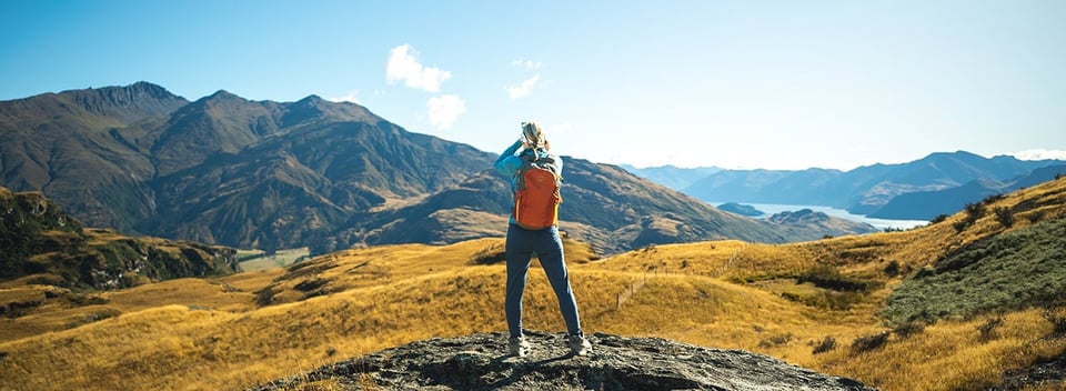
New Zealand Mountains

Stomping ground of legendary explorers and source of inspiration for countless artists, poets and storytellers, New Zealand’s vast peaks and snow-capped pinnacles typify a landscape of extremes. Rising sharply from the earth and sea, the New Zealand mountains run like a majestic backbone down the country, their rugged beauty never failing to impress.
The tallest mountains in New Zealand have long served as motivation for serious mountaineers and hikers intent on scaling the heights. Fortunately for us mere mortals, some of the most impressive hiking in New Zealand and its mountain ranges is still accessible to those without ice picks and crampon skills!
Visitors from around the globe make the trip to New Zealand’s shores to marvel at the mountains. And that journey is never in vain – New Zealand’s mountain ranges are even more breath-taking in real life, leaving many a hiker lost for words as they gaze up at the rocky outcrops, swirling mists and snowy heights above.
According to Māori legend, how were the mountains of New Zealand formed?
Māori tradition tells that New Zealand’s mountains were once gods and warriors whose fierce battles forged the landscape. Viewed as sacred sites, the Māori people have deep respect for the mountains in New Zealand and an unwavering bond with the land.
Special reverence is given to the tallest mountains in New Zealand and the rich mythology that accompanies them. To stand atop a mountain peak is to stand on top of an ancestor, hence the reason why many Māori will not stand on the very top of a mountain. Educational tools and guidance are provided to climbers and guides who seek to summit New Zealand’s peaks to ensure that respect is maintained for the sacred nature of the mountains.
In this piece, we will compile a list of the most notable mountains in New Zealand and showcase the 7 most stunning peaks. Additionally, we will delve into the rich Māori legends and tales that bring the New Zealand landscape to life.
1. Aoraki/ Mount Cook
Height: 3,724m (12,218 ft)
Grade: 3-4

You'll have the opportunity to stand at the foot of New Zealand's tallest mountain on any of our South Island tours.
The tallest mountain in New Zealand, Aoraki/Mount Cook is known as the ‘cloud-piercer’, and when its snowy heights are revealed behind the white mist, you’ll understand its significance to the New Zealand people. Part of the Southern Alps mountain chain and lying at the centre of the 650km long active Alpine Fault, Aoraki was formed as the Pacific and Indo-Australian tectonic plates collided. The mountain continues to grow even today, rising an average of 7mm (0.28in) each year.
To the Ngãi Tahu people, Aoraki is the most sacred of peaks, linking the natural and supernatural worlds. Māori legend tells that Aoraki was the son of Rakinui, the Sky Father. Aoraki’s canoe became stranded on a reef during a voyage and tilted up. Along with his three brothers, Aoraki climbed on top of the canoe where the south wind froze them place, turning them into stone and creating the Southern Alps.
Serving as a training ground to none other than Sir Edmund Hillary himself, who went on to summit Mount Everest in 1953, Aoraki/Mount Cook and the surrounding area is widely regarded as the best mountaineering in Australasia. Luckily there’s plenty for non-mountaineers to enjoy as well. Beautiful lower level hikes lead walkers through stunning alpine scenery with views typically reserved for serious mountaineers only. Glaciers, lakes complete with icebergs, herb fields and cheeky local wildlife like the Kea (the world’s only alpine parrot!) ensure that visitors to the area are not disappointed.
Where in New Zealand is Aoraki/Mount Cook?
The tallest mountain in New Zealand is in the central South Island, nestled deep within the heart of the Southern Alps in Mount Cook National Park. Surrounded by towering peaks and pristine scenery, the small Aoraki/Mount Cook Village lies at the foot of the mountain. An International Dark Sky Reserve, it’s the perfect place for star gazing at night when you’re not staring at the mountain during the day!
Access to Aoraki/Mount Cook: First summited in 1894 by three New Zealanders, the peak is accessible only to experienced mountaineers. However, there are lots of lower-level walks and hikes that provide excellent views of the mountain. You can also get up close with the icebergs on a boat ride or take a helicopter up to the Tasman Glacier for breathtaking vistas.
You can explore Aoraki/Mount Cook National Park on any of our South Island New Zealand Trails trips – it’s one of New Zealand’s top experiences!
2. Mount Ruapehu
Height: 2,797m (9,177 ft)

Admire Ruapehu as you make your way through the North Island - or up close and personal if you're well equipped!
Mount Ruapehu is the largest active New Zealand volcano and the highest point on the North Island. Its imposing form dominates the landscape, with its three peaks snow-capped in winter then revealing rugged volcanic rock over the summer months. Sitting at the southern end of the Taupo Volcanic Zone, this stratovolcano made up of layers of lava and ash is one of the world’s most active, most recently erupting in 2006.
In Māori tradition, Ruapehu was a beautiful maid whose infidelity resulted in an epic battle between her husband, Taranaki and her lover, Tongariro. The battle was eventually won by the rival lover, but Ruapehu still misses her husband to this day and sighs as she remembers him, releasing a mist. Tongariro, the rival, despite the victory, is angry, smoking and smouldering in fury.
Lord of the Rings fans might recognise the landscape of Mount Ruapehu as the fictional Mount Doom from the film trilogy!
Where in New Zealand is Mount Ruapehu?
Mount Ruapehu is located within the Tongariro National Park in the central North Island of New Zealand, an area with dual World Heritage status. The closest towns are Ohakune to the northeast and Taupo to the southwest, both 23km (14 mi) away.
Access to Mount Ruapehu: With unimpeded views right to the coast, this stunning part of the country is accessible year-round to hikers, skiers, snowboarders and nature lovers. There are two commercial ski fields, with a hike from the chairlift up to the summit and crater lake possible with the correct equipment.
You can also enjoy Mount Ruapehu’s majesty from the Tongariro Crossing, one of New Zealand’s Great Walks. You can hike the Crossing with us on our Sweet North trip!
3.Mount Tongariro
Height: 1,978m (6,490 ft)

The otherworldly views from the Tongariro Alpine Crossing.
Another New Zealand volcano, Mount Tongariro was formed by multiple eruptions over many years from its 12 cones, commencing some 275,000 years ago. Ancient and impressive, Mount Tongariro is a world-famous hiking destination with a complex landscape of craters, alpine lakes and smoking vents. Māori legend plays out on the landscape to this day, and visitors to the area enjoy uncovering more of the story as they hike.
Tongariro became New Zealand’s first National Park in September 1887 when a local Māori Chief gifted the land to the people of New Zealand. It is New Zealand’s oldest National Park and its dual World Heritage status recognises the cultural significance of the land, as well as its impressive volcanic features.
Where in New Zealand is Mount Tongariro?
Situated in its namesake, Tongariro National Park is located halfway between Auckland and Wellington on the North Island of New Zealand.
Access to Mount Tongariro: Heralded as the “best day hike in the world”, the Tongariro Crossing is well-deserving of the title. This 19.4km (12 mi) hike offers stunning scenery and panoramic views. Because of the active volcanic nature of the landscape, multiple hazards exist, and weather conditions can have a big impact on your hike. We recommend hiking the track with an experienced guide to make the most of the walk.
Request a free copy of our brochure to find out more about how you can explore the Tongariro Crossing with New Zealand Trails.
4. Tititea (Mount Aspiring)
Height: 3,033m (9,951 ft)
Grade: 3

The sheer cliff faces of Mt Aspiring create visual drama that has to be seen to be believed.
Outside of the Aoraki/Mt Cook area, Mount Aspiring is the tallest mountain in New Zealand, placing 23rd by height in the list of mountains in New Zealand. Tititea can be translated as ‘glistening peak’ or ‘steep peak of sparkling white’ - an apt description for this beautiful but rugged mountain. Carrying on the theme of alternative descriptions, Mount Aspiring has also been called the ‘Matterhorn of the South’ due to its pyramid-shaped peak.
The local landscape formed over time through intense glaciation, and today three large glaciers flank the mountain, draining into surrounding rivers. Early Māori passed through the region to collect food and pounamu (greenstone). In fact, their ‘Greenstone trails’ cut through mountain passes are still in use today. Tititea (Mount Aspiring) is part of the Te Wähipounamu South West New Zealand World Heritage Area, a title that signifies its natural and cultural world significance.
Where in New Zealand is Mount Aspiring?
Located in Mount Aspiring National Park on the South Island, one of New Zealand’s largest and least developed National Parks, it spans some 355,543ha. The closest towns are Wanaka, Queenstown, Glenorchy and Te Anau – all great bases to explore the area and view the peak.
Access to Mount Aspiring: Part of the Southern Alps, Mount Aspiring draws visitors from all around and while the peak is off-limits to all but the hardiest climbers, there are many fantastic day and overnight hikes in the area.
Hike the famous Routeburn Track to experience the sights and sounds of Mount Aspiring National Park, or take to the skies for an incredible aerial view on our Pure South trip.
5. Rahotu (Mitre Peak)
Height: 1,690m (5,560ft)
Grade: 2

The stunning heart of Milford Sound - it's easy to see why Mitre Peak graces so many postcards!
Early Māori travelled to Milford Sound overland, following a route that has become the Milford Track as we know it today. They named the peak Rahotu, after an ancestral man from Taranaki – whose conduct was apparently not very becoming of a mitre, but nevertheless, the name stuck!
Where in New Zealand is Mitre Peak?
Situated in Fiordland, the largest of New Zealand’s National Parks, Mitre Peak is a prominent feature on the south shore of Milford Sound. You can spend the night in Milford Sound, either aboard a purpose-built vessel or in the homely Milford Lodge. The closest township is Te Anau, gateway to Fiordland and with a wealth of exceptional hikes.
Access to Mitre Peak: There are six routes up Mitre Peak, although it’s a demanding climb reserved for experienced mountaineers. The best way to experience Mitre Peak for those not familiar with rock climbing techniques is on a boat cruise of the fiord.
We visit Milford Sound on all our South Island tours and you’ll enjoy a chance to witness the natural wonder of Mitre Peak up close. Discover five reasons Milford Sound is best visited in the rain and find out how you can get there by getting in touch with us.
6. Horokoau (Mount Tasman)
Height: 3,497m (11,473 ft)
Grade: 3+

Mt Tasman peeks out over Lake Matheson - a spot we eagerly visit on our South Island tours.
Mount Tasman is the second tallest mountain in New Zealand, closely neighbouring Aoraki/ Mount Cook and bedecked with a glittering snowy crown. Considered by many to be New Zealand’s most beautiful peak, it is a popular but intensely challenging climb for mountaineers.
The Māori name Horokoau is believed to refer to the swelling in the neck of a shag bird when it’s swallowing a fish. It’s also known by another Māori name, Rarakiroa, the brother of Aoraki/ Mount Cook, who stood together atop their upturned waka (canoe) of the South Island, turned to stone by the icy winds and forming the mountainous landscape as we see it today.
Where in New Zealand is Mount Tasman?
Four kilometres north of its taller brother, Mount Tasman is in the Aoraki/Mount Cook National Park. All of New Zealand’s peaks over 3000m are found in the Southern Alps, making it one of the most impressive mountainous landscapes in the world.
Access to Mount Tasman: Mount Tasman’s towering peak is covered in snow and ice and presents a challenge to even the most technically experienced climber. For those understandably disinclined to summit, incredible views can be had on a clear day from the West Coast of New Zealand’s South Island.
Experience this mountainous wonderland on our Masterpiece tour that takes you right around the South Island and into the heart of the mountains in New Zealand.
7. Kawarau (The Remarkables)
Height: 2,319M (7,608 ft)
Grade: 1

Despite the plethora of mountains in the Wakatipu Basin, the Remarkables still stand proud as the most stunning (and tallest!) in the area.
The Māori Name Kawarau can be broken down to find its meaning; ‘kawa' meaning bitter or pointed and 'rau' meaning many. The river at the foot of the mountains is also named Kawarau, after a Māori chief who was highly esteemed by his people.
Where in New Zealand are The Remarkables?
Providing a stunning backdrop to the adventure capital of the world, The Remarkables is a short but scenic drive from Queenstown. Enjoy incredible views of the mountain peaks from the centre of town or get a panoramic vista of the Wakatipu Basin by driving a short way up the access road.
Access to The Remarkables: An access road allows you to drive almost to the top of the mountain. During the winter months, the highest points can be reached via chairlift or alpine hiking. They will be snow-covered, so be prepared. Summer is also a popular time for hikers and there are various routes available, some more challenging than others. You might also spot the odd mountain biker speeding down the lower-level peaks and troughs.
Queenstown is our home and we love the jaw-dropping effect The Remarkables has on our guests when they visit. Explore with us on an outstanding small group tour and discover the real New Zealand with the locals!
That about wraps up our list of mountains in New Zealand. The 7 we’ve listed are some of our favourites, but with hundreds to choose from, you might well find your own inspiration on your travels! If you're interested to learn more and find out the easiest way to sample our majestic mountains check out our New Zealand hiking tours.
 Share
Share
 Tweet
Tweet
 Email
Email
 Share
Share
Recent articles


Explore New Zealand
Walking and Hiking- Best Day Hikes in Fiordland National Park
- Hiking the Milford Track in October
- Hiking the Kepler Track in October
- Hiking the Kepler Track in Winter | Weather Guide
- Hiking the Kepler Track in February
- Hiking the Kepler Track in January
- Hiking the Kepler Track in December
- Heaphy Track Weather Guide for Hikers
- Lake Waikaremoana Track
- Milford Track Weather Guide for Hikers
- The Routeburn Track Weather Guide for Hikers
- Kepler Track Weather Guide For Hikers
- 13 Best Multi-Day Hikes in the South Island, New Zealand
- Exploring New Zealand’s Siberia Valley
- Day Walks on New Zealand's Great Walks - South Island
- Hiking the Rakiura Track, Stewart Island's Great Walk
- The Kepler Track | A Complete Guide
- Hiking in New Zealand for Your Bucket List
- 12 Best New Zealand Day Hikes
- Hiking the Milford Track in New Zealand
- The Top 10 Lesser Known Walks of New Zealand
- Great Walks of New Zealand
- Luxury Hiking in New Zealand
- Best Walks in New Zealand
- Routeburn & Milford Track | Best Day Hikes
- Why More Travellers Are Choosing Guided Adventure Tours in New Zealand
- Caring for Aotearoa - What is the Tiaki Promise?
- Conservation & Regeneration At New Zealand Trails
- The Routeburn Track Weather Guide for Hikers
- Kepler Track Weather Guide For Hikers
- The Perfect Trip to Replace Your Cancelled REI New Zealand Adventure
- Keeping You Safe in the Post Covid-19 Era
- New Zealand Accommodation on our Trips
- The Finer Touches at New Zealand Trails
- Kiwi Hospitality and the New Zealand Way
- The Qualmark Gold Standard Award
- The Best New Zealand Small Group Tours
- 3 Dream Places to Stay in New Zealand
- Our Best Photos of New Zealand from 2017-2018
- Hiking in New Zealand 2016 Season
- Why Join a Guided New Zealand Hiking Tour?
- Exploring New Zealand's World Heritage Sites
- Hiking the Kepler Track in February
- New Zealand Cuisine | Food in New Zealand
- A Guide to New Zealand Wine Regions
- Guide to New Zealand’s Coffee Culture
- Women Travelling Together - New Zealand Group Tours For Women
- Travel Solo, Not Alone: Group Tours for Solo Travellers
- The Rise of Solo Travel in New Zealand: Taking the Scenic Route on Your Own
- New Zealand - The Perfect Place For Solo Travel
- Why Autumn is the Best Time to Visit New Zealand
- Travel Tips for Hiking in New Zealand
- New Zealand's Best Waterfalls
- The Best Places to Visit on New Zealand's West Coast
- Top 10 New Zealand Adventures
- Hiking the Kepler Track in November
- The Best South Island New Zealand Adventures
- Top Tips for your Free Day
- The ultimate New Zealand luxury tour - Part 2
- The ultimate New Zealand luxury tour - Part 1
- Why do a New Zealand guided hiking tour?
- Our New Zealand Hiking Guides
- Hiking the Kepler Track in January
- Heaphy Track Weather Guide for Hikers
- Milford Track Weather Guide for Hikers
- Kepler Track Weather Guide For Hikers
- 10 Best Places to Kayak in New Zealand
- Riding the Queenstown Trail
- Sounds of New Zealand - New Zealand Music
- 9 Must-See New Zealand Movies
- 10 of the Best New Zealand Books
- 13 Things You May Not Know About New Zealand
- How to book your New Zealand trip
- 10 South Island Secrets
- Why Do I Need New Zealand Travel Insurance?
- New Zealand Solo Travel and Hiking
- What Is the Best Way to Travel New Zealand?
- Australia vs New Zealand | Which is Best?
- What to Pack for New Zealand
- World Heritage Walking Tour - Is It For Me?
- Flights to New Zealand: How to Get Here
- When is the Best Time to Visit New Zealand?
- Conservation & Regeneration At New Zealand Trails
- Why October is a great time to visit Stewart Island
- Hiking the Routeburn Track in Winter
- Hiking the Milford Track in Winter
- Hiking the Milford Track in December
- Hiking the Milford Track in November
- Hiking the Milford Track in October
- Hiking the Kepler Track in November
- Hiking the Kepler Track in October
- Hiking the Kepler Track in Winter | Weather Guide
- Hiking the Kepler Track in March
- Hiking the Kepler Track in February
- Hiking the Kepler Track in January
- Hiking the Kepler Track in December
- Heaphy Track Weather Guide for Hikers
- Milford Track Weather Guide for Hikers
- The Routeburn Track Weather Guide for Hikers
- Kepler Track Weather Guide For Hikers
- Best places to visit during spring in New Zealand
- What’s the Best Time for Hiking in New Zealand?
- Spring in New Zealand – A Special Time of Year!
- New Zealand Seasons: Which One Suits You Best?
- When is the Best Time to Visit New Zealand?
- 5 Reasons to Visit During Spring in New Zealand
- Why You’ll Love Spring Hiking in New Zealand
- A Journey Through Time: The Whanganui River Journey
- The Best Places to Visit on New Zealand's West Coast
- Travel like it used to be | 24 hours on Stewart Island
- Top 10 New Zealand Adventures
- Top Tips for your Free Day
- The Most Beautiful Lakes In The South Island
- Hiking the Kepler Track in January
- Arrowtown - A Few Hours To Explore
- Top 15 things to do in Queenstown
- Top 5 things to do on Stewart Island
- The Best Beaches in New Zealand
- 10 of New Zealand's Best Backroad Experiences
- New Zealand Bucket List... with a Twist
- New Zealand Tours | Lord of the Rings
- New Zealand National Parks | A Complete Guide
- New Zealand Mountains
- North vs South Island | Which To Visit?
- Hike and Kayak Abel Tasman National Park
- Queenstown | Adventure Capital of the World
- 5 Reasons Milford Sound is Best in the Rain
- 24 Hours in Queenstown
- Walking the Hollyford Track
- Hiking the Routeburn Track
- The Best Glacier Hiking in New Zealand
- Castle Hill and Arthurs Pass Hiking
- New Zealand Penguins
- New Zealand Birds - NZ's Unique Parrots
- Conservation in New Zealand – Protecting New Zealand’s Kiwi Bird
- New Zealand Nature: What to Expect
- Kiwi Bird | The New Zealand National Bird
- New Zealand Wildlife | Our Top 14 NZ Animals
- Top 5 New Zealand Hiking Destinations
- Best Autumn Hikes in New Zealand
- Hiking the Routeburn Track in Winter
- Hiking the Milford Track in Winter
- Hiking the Routeburn Track in October
- Hiking the Milford Track in December
- Hiking the Milford Track in November
- Hiking the Milford Track in October
- Hiking the Kepler Track in November
- Hiking the Kepler Track in October
- Hiking the Kepler Track in Winter | Weather Guide
- Hiking the Kepler Track in January
- The Routeburn Track Weather Guide for Hikers
- Kepler Track Weather Guide For Hikers
- The Ultimate Guide to Hiking in New Zealand
- Top 10 Tips to Keep You Safe on the Trails
- Keep Safe with Mountain Safety Council
- The Ultimate New Zealand Packing List
- Hiking New Zealand Guide
- Hiking Preparation - 5 Tips To Get Ready
- How to Use Trekking Poles Video
- How to Choose Hiking Boots Video
- What to Wear Hiking in New Zealand Video
- The Best Time to Hike the Milford Track
- The Best South Island New Zealand Adventures
- Top Tips for your Free Day
- Hiking the Kepler Track in February
- Top 15 things to do in Queenstown
- 10 of New Zealand's Favourite Sports
- The Best Spots for Stargazing in New Zealand
- Top 50 Best Things To Do In New Zealand
- Scenic Flight into the NZ Wilderness
- Nile River Glow Worm Caves & Punakaiki
- Travel like it used to be | 24 hours on Stewart Island
- The Most Beautiful Lakes In The South Island
- Visiting Doubtful Sound
- Geothermal New Zealand | Rotorua
- New Zealand Redwoods Forest
- Waitomo Caves
- Exploring Cathedral Cove
- Huka Falls & Lake Taupo
- Exploring the Coromandel Coast
- The Kepler Track | A Complete Guide
- Hiking Mt Crichton Loop Track
- Things to do in Christchurch
- The Ultimate Guide to the Routeburn Track
- Fiordland National Park
- Franz Josef Glacier
- Queen Charlotte Sound & Marlborough Wineries
- Kaikoura Peninsula
- Ben Lomond | Queenstown’s best day hike
- Mount Aspiring National Park
- Lake Tekapo & Mount John
- Paparoa National Park
- Okarito | A Complete Guide
- Arthur's Pass New Zealand
- Tongariro Crossing
- Guide to Aoraki/Mt Cook National Park
- The Ultimate Guide to Visiting Milford Sound
- Mou Waho Island | Wanaka
Search Articles

World HeritageMarch 2023"We travel frequently for business and leisure and are pretty critical. This trip was by far our best, most enjoyable travel experience ever. As I have mentioned in earlier comments the thought and planning that went into the planning of the trip was evident at every turn."
- George Stapleton