The Ultimate Guide to the Routeburn Track

The Routeburn Track has a well-deserved reputation as one of New Zealand's best hikes and is a favourite hiking experience for both Kiwis and overseas visitors alike. The track itself is a 32km long trail located in New Zealand's beautiful South Island running between the Routeburn Shelter, near Glenorchy, and The Divide in Fiordland National Park. Known for its stunning landscapes, diverse flora and fauna and awe-inspiring vistas the Routeburn Track has well and truly earned it's place among New Zealand's 10 Great Walks.
If you're looking for the ultimate guide to hiking this incredible trail than look no further! Here's our ultimate guide to the Routeburn Track including the best times to hike, what to pack, track highlights and more!

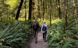
Our wonderful guests enjoying the epic scenery on the Routeburn Track.
A few fun facts about the Routeburn Track
-
With a history that is anything but brief, the Routeburn Track had all the makings of a true classic from the very beginning. It is believed that the route was once frequented by Maori as early as the 1500s for passage to the Dart and Arahura Rivers, in search of highly prized Pounamu (greenstone). Pioneering Europeans began the first mapping of the area in 1861, with David McKellar and George Gunn surveying the landscape for potential grazing country.
-
The pursuit of grass quickly gave way to gold, and following its discovery, the government ordered the construction of a track for its transportation. However, this project was abandoned and never completed but the first trail was now cut. In the 1880s it had become obvious that this trail had assets even greater than its dwindling gold supply, and the first explorers and tourists began to hike the track and its fantastic scenic backcountry. The present-day trail follows the original explorers’ route, with its natural assets cementing the future of the Routeburn as we know it today. As they say – the rest is history!
-
As for flora and fauna, the trail is a favourite haunt of the bush robin and, near Routeburn Flats, sightings of yellowhead (mohua) are a special privilege. Fortunate hikers may even catch a glimpse of the rare blue duck (whio) which resides in the higher stretches of the river – often revealed by their shrill, distinctive call. Native parrots also inhabit this wilderness, including parakeets (kākāriki), kaka and of course the cheeky kea - normally seen flying high overhead, squawking enthusiastically. Higher up and beyond the verdant, mossy beech forests, fields of alpine herbs dress the landscape in vibrant hues with colourful daisies, bluebells, gentians, hebes and coprosma, among others. You'll also see patches of ribbon wood trees – one of New Zealand's only deciduous natives.

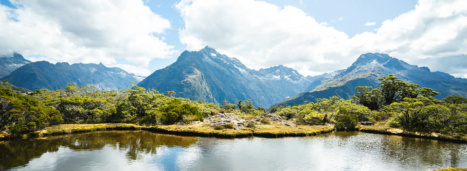
The hike to Key Summit on the Routeburn Track is a fantastic day walk.
Best time to hike the Routeburn Track
Winding its way through breath-taking South Island alpine scenery, New Zealand's Routeburn Track is open year-round but the best time of year to hike this trail depends largely on how you would like to experience its changeable moods. Showcasing sections of both Fiordland and Mount Aspiring National Parks, enchanting rainforests, grand mountain vistas, majestic waterfalls and clear flowing rivers characterise the Routeburn. Though the track is open year round, winter hiking can be extremely challenging and even dangerous at times due to the changeable nature of the weather in these alpine conditions. For this reason most hikers, including those on our New Zealand hiking tours, choose to tackle the trail between October and early May.
During this time, the weather is generally mild and the trail is well maintained. However, being an alpine environment it's always important to be prepared for sudden changes of weather.
Routeburn Track weather
The environments surrounding the Routeburn are renowned for climatic extremes, so regardless of the season, it pays to be prepared for a range of weather conditions. The best hiking begins in spring (September to November in the Southern Hemisphere) when vast fields of the famous Mount Cook buttercup (Ranunculus lyallii) are in full flower. Spring temperature averages range from 9°C (48°F) - 17°C (62°F).
The summer months of December, January and February bring the highest temperatures on the trail, averaging 10°C (50°F) - 18°C (64°F) and reaching a maximum of 28°C (82°F). Despite this, cold snaps can occur at any time and low temperatures can fall below 0°C (32°F), so don't forget to pack your warm gear. February is generally the driest month of the year with an average of only nine rainy days.
Late autumn (April and May) can be characterised by the first snowfall on the mountains, with average temperatures sitting between 8°C (46°F) - 16°C (61°F).
Weather on the Routeburn Track during winter brings temperatures between 1°C (34°F) - 9°C (48°F), and snow is common. The Department of Conservation discourages walkers on the Routeburn Track between early May and late October because of the more challenging conditions. Sections of the trail can become impassable and specialist equipment is required during this time, so we recommend leaving it to the experts.
Regardless of the season, the rivers and rainforests of the Routeburn Track are nourished by some impressive rainfall, averaging around 7m (23ft) per year. Far from discouraging, this precipitation can bring with it some incredible spectacles in the form of rushing rivers and tumbling waterfalls. That's not to say it rains every day on the Routeburn – especially over our summer months warm, golden sunshine is a common mood of these mountains, bringing with it stunning alpine views and very pleasant hiking conditions.

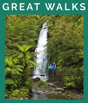
Explore the beauty of the Routeburn Track and weave through the native forest.
Routeburn Track highlights
This grand, mountainous trail is home to some of the finest scenery in the country. It's hardly surprising that the area has been designated a World Heritage Site. The Routeburn Track explores 32km (19 miles) of countryside over 2-4 days, incorporating sections of both Fiordland and Mount Aspiring National Parks. Setting out, you'll meander through ancient beech forest, enjoying birdlife and regular views of the pristine waterways which are often forded by classic kiwi swing bridges.
The Routeburn River and gorge are always highlights, as is the incredible Hollyford face. Eventually, beech forest gives way to grassy river flats and wide-open spaces before hikers begin the gradual climb into the high country. Continuing onwards, the great walk reveals spectacular alpine meadows and the picturesque alpine lakes of Harris and MacKenzie, in addition to several jewel-like tarns which, on clear days, can offer some wonderful reflections of the surrounding landscapes. Though your pack may be heavy if taking on the track in its entirety, the grand views from high on the Routeburn extend to the Darran Mountains and the Tasman Sea and make for some spectacular photos so don't forget your camera! There are also many waterfalls dotted along the way, including the impressive Earland and Routeburn Falls.

Our guests enjoying the stunning views from Key Summit.
Routeburn Track huts and camping
As is common on New Zealand's Great Walks, DOC (the Department of Conservation) operates a system of huts along the Routeburn Track, including the Routeburn Flats Hut, Lake Mackenzie Hut and Routeburn Falls Hut. During Great Walks season these huts must be booked and provide basic amenities including bunks, gas stoves and toilets. Camping is also permitted in designated campsites along the trail, but again, you'll need to book in advance.
Staying safe on the Routeburn Track
The Routeburn Track can be a challenging trail so if travelling on your alone or un-guided it's important to take precautions and follow safety guidelines. (Alternatively if you're travelling with us you can sit back and relax knowing all your safety concerns are taken care of by our expert local guides.)
If you're going alone here are a few handy tools that can help you stay safe on the trails:
- Make sure you have a map. Something like Topomap is a great resource for easy access to a detailed map on your phone.
- Check the DOC website for track updates, latest weather forecasts and any important information you might need to know before setting of.
- Check New Zealand Mountain Safety Council for a number of handy tips and useful tools
- Consider renting a PLB. These can be hired throughout New Zealand from a number outdoor retailers.
- Be prepared for the conditions. Check the weather forecast before you set off and pack appropriately.
Routeburn Track packing list
When preparing for the Routeburn Track you'll need to make sure to pack appropriately. If you're doing the full 3 day tramp (Kiwi slang for multi-day hike) you'll want to pack efficiently, keeping weight down without skimping on the essentials.
Here's a list of the most important items for the Routeburn Track's changeable weather conditions:
- A good waterproof jacket
- A windproof fleece or sweater
- A non-cotton base layer (top and bottom) - We love to use local Merino wool.
- Good quality hiking boots with plenty of support
- Proper walking socks - there's nothing worse than uncomfortable feet when hiking
- Quick dry outer layers - t-shirt and/or long sleeved t-shirt and long pants or shorts
- A good hat and quality sunglasses
- A comfortable pack - size depending on whether you're day hiking or spending multiple days
- Water bottles or a bladder
Depending on if you're planning to hike the full track or enjoy the best parts on a day-hike you may also need a sleeping bag, food and a dry, warm change of clothes for the evening.

The magnificent Routeburn Track.
Tips to hiking the Routeburn Track
Where to begin
Because the track has road access to both ends, there are two possible starting points for your Routeburn adventure. The most popular is from the Routeburn Shelter end of the trail, located close to the beautiful town of Glenorchy. This end of the track is easily accessed by a short, stunning drive from Queenstown. The alternative involves setting out from The Divide Shelter, located in the heart of Fiordland National Park on the Milford Road which connects Te Anau with Milford Sound. There are a range of transport options to and from either end.
Hiking the Routeburn Track with New Zealand Trails
Often, it may not be possible to fit the full 32 km (19 miles) multi-day hike of the Routeburn Track into a vacation schedule so a day walk on the trail might be the best answer. This way, you'll experience the grandeur and some of the trail's special sights without the need to complete the full distance. On our fully guided New Zealand hiking tours, we sample the best of the Routeburn without having to worry about crowded huts or big heavy packs. Depending on which of our trips you've chosen we'll sample the Routeburn Track from either Routeburn Shelter or The Divide. On our Grand Explorer and World Heritage tours we'll begin from Routeburn Shelter, journeying through stunning beech forests just like the filming locations from Lord of the Rings, winding our way to Routeburn Flats beside the crystal-clear river. For the brave, a cool dip is highly refreshing! If you're after a challenge, there is also the option of the hike to Routeburn Falls, where you’ll be rewarded with spectacular views of the valley, mountains and beyond. On all our other South Island tours (Masterpiece, Kiwi Classic, and Pure South), you will experience the Routeburn Track from the other end, hiking up to the spectacular Key Summit.
If you want to find out more about the incredible 5-14 day hiking tours we run in New Zealand, you can request a free copy of our brochure here.
 Share
Share
 Tweet
Tweet
 Email
Email
 Share
Share